Wednesday, 30 April 2014

Kihei Maui

Kihei is beach-combing territory on Maui’s southwest shore, the sunniest, driest end of the island. Once a regular destination for sojourning Hawaiian royalty, Kihei features six miles of beaches, which offer clear views of Kahoolawe, Molokini, Lanai and West Maui. Along with swimming and surfing you can also find great snorkeling and kayaking, and you may even spot a giant humpback whale spouting or breaching the ocean’s surface.

Kihei’s Kalama Beach Park has shady lawns and palm trees dotting its 36-oceanfront acres. A blink away are Kalpolepo, Waipuilani and the three beaches of Kamaole. Birdwatchers and nature lovers will find what they’re looking for at Kealia Pond on the north end of Kihei. This National Wildlife Conservation District features endangered Hawaiian stilts and coots.


Also north of Kihei is Maalaea Bay, where pleasure boats launch to take visitors on whale watching expeditions, charter fishing excursions and snorkel trips to Molokini. Maalaea is also home to the family friendly Maui Ocean Center.


{ Read More }


Tuesday, 29 April 2014

St. Lucia

St. Lucia is the sort of island that travellers to the Caribbean dream about--a small, lush tropical gem that is still relatively unknown. One of the Windward Islands of the Lesser Antilles, it is located midway down the Eastern Caribbean chain, between Martinique and St. Vincent, and north of Barbados. St. Lucia is only 27 miles long and 14 miles wide, with a shape that is said to resemble either a mango or an avocado (depending on your taste). The Atlantic Ocean kisses its eastern shore, while the beaches of the west coast owe their beauty to the calm Caribbean Sea.

In natural beauty, St. Lucia seems like an island plucked from the South Pacific and set down in the Caribbean. Its dramatic twin coastal peaks, the Pitons, soar 2,000 feet up from the sea, sheltering magnificent rain forests where wild orchids, giant ferns, and birds of paradise flourish. Brilliantly-plumed tropical birds abound, including endangered species like the indigenous St. Lucia parrot. The rainforest is broken only by verdant fields and orchards of banana, coconut, mango, and papaya trees.

St. Lucia has been inhabited since long before colonial times, and its cultural treasures are a fascinating melange of its rich past and its many different traditions. The island's people have earned a well-deserved reputation for their warmth and charm, and the island itself is dotted with aged fortresses, small villages, and open-air markets.


There is a broad array of exciting and exotic activities available on St. Lucia. The island's steep coastlines and lovely reefs offer excellent snorkeling and scuba diving. The rainforest preserves of St. Lucia's mountainous interior are one of the Caribbean's finest locales for hiking and birdwatching. Of course, the island also possesses excellent facilities for golf, tennis, sailing, and a host of other leisure pursuits. Not to be missed is St. Lucia's Soufriere volcano, the world's only drive-in volcanic crater.


{ Read More }


Sunday, 27 April 2014

Bridge of Sighs, Venice, Italy

Venice's famous Bridge of Sighs was designed by Antonio Contino and was built at the beginning of the 17th century. Spanning the Rio di Palazzo (Palace River), the bridge  Bridge of Sighs, Venicewas intended to connect the Old Prison and interrogation rooms in the Doge's Palace to the New Prison, which was situated directly across the river.

There are a few theories as to how the bridge got its name. The first one involves the prisoners that walked across the bridge on their way to the executioner. The prisoners would "sigh" as they crossed the bridge, probably catching their last glimpse of the outside world, many believed.
Even though by the time the bridge was built summary executions at the hands of the inquisitors had ceased, many prisoners probably did cross the bridge and may have not seen freedom again... at least not for many years.

Another story says that if a couple kisses under the bridge Bridge of Sighs, Venicewhile drifting below on a gondola at sunset, they will enjoy eternal love. Thus, the "sighs" are said to come from lovers who are overwhelmed by the romance of the whole scene.
This romantic view was created by the Poet Lord Byron with his writings: "I stood in Venice on the Bridge of Sighs, a palace and prison on each hand".


{ Read More }


Wednesday, 23 April 2014

Havasu Falls, Arizona

Havasu Falls is paradise on Earth. This is an absolutely amazingly beautiful waterfall located in a remote canyon of Arizona. It takes a good deal of effort to get there, but the reward is worth it. It was even more beautiful than we could have imagined (and we had seen plenty of pictures of the waterfall beforehand - hence the reason we wanted to go there in the first place). If you go to Havasu Falls, you will no doubt think you are somewhere in Hawaii. It is an oasis in arid Arizona.

The hike to Havasu Falls begins at Hualapai Hilltop, about 100 miles from Seligman, the nearest town. Many people stay at Seligman the night before hiking into Havasu, then get up early and drive to the hilltop. We stayed at Sedona, a 3 hour drive away (it was free for us, to stay with my parents there). The first 1.5 miles of the hike is a steep descent down to the bottom of Hualapai Canyon (1000 ft. elevation loss). Remember this descent because you will have to go back up it when you climb back out of the canyon (at the end of a long 10 mile hike). The rest of the hike is mostly flat (6.5 miles to the village, or 8.5 miles to the campground). It is an absolutely beautiful hike along the bottom of Hualapai Canyon, an amazing experience hiking through a steep canyon with the cliffs towering above you. But it is also a long hike. It seemed that the canyon was never-ending. We kept looking around the next corner for the end of the canyon, where it finally joined up with Havasu Canyon and creek, but it never seemed to come. Eventually though, you will reach Havasu Creek. From there it is about a 1.5 mile hike to the village of Supai, as you hike through Havasu Canyon now, along Havasu Creek. Havasu Creek is one of the most beautiful creeks we have ever seen, with amazingly clear blue-green waters. The name "Havasupai" means "people of the blue-green waters", and it is easy to see where this name comes from.


Havasu Falls is a 2 mile hike past the village, located just before the campground. It is a beautiful double waterfall along Havasu Creek, falling into a crystal clear pool, perfect for swimming on a hot day. There is a large beach area for lounging and picniking in front of the waterfall. You can also get to the top of the waterfall and look down (but be careful). There is something very alluring about this waterfall. It is one you just have to see to believe.


{ Read More }


Sunday, 20 April 2014

Provence Alpes

The region Provence-Alpes-Côte d’Azur is a French administrative region from the south-east of the country. It is often referred to by the acronym PACA.

The region is situated next to Italy from which it is separated by the Southern Alps. Up north, there is the Rhônes-Alpes region and, to the west, the Rhône River, which indicates the border with the Languedoc-Roussillon region. The PACA region is bordered down south by the Mediterranean Sea.


The PACA region gathers six departments, formerly from the Ancien Régime provinces of Provence and Dauphiné. A part of the Vaucluse department is constituted by the annexation of the Comtat Venaissin during the revolutionary period, as well as for the Alpes-Maritimes region with the left bank of the Var River, which was the County of Nice annexed to France in 1860 during the Second Empire (the County of Nice was an old part of the duchy of Provence before 1388, when Nice devoted itself to Savoy). The logo of the Regional Council reminds all four regions, resuming their former prestige gathered under the same flag.


{ Read More }


Saturday, 19 April 2014

Nassau, Bahamas

Nassau, the capital city of The Bahamas, is located on 21-mile-long New Providence, our 11th largest island. Nassau’s main harbor is protected by Paradise Island. The harbor attracted settlers in the early days, particularly pirates. In fact, Nassau’s population consisted mainly of pirates until 1718, when The Bahamas first Royal Governor, Woodes Rogers expelled them, restored order and built Fort Nassau. The Bahamas for centuries adopted Rogers’ motto, “Expulsis Piratis, Restituta Commercia,” which means, “Pirates Expelled, Commerce Restored.” Now, 212,000 people call New Providence Island home, with a large portion of them residing in Nassau.


{ Read More }


Wednesday, 16 April 2014

Kawasan Falls, Cebu, Philippines

Kawasan Falls in Badian, Cebu kawasan falls Cebu is a peaceful natural place where you can enjoy many waterfalls of natural spring water located near the southern tip of Cebu Philippines. A gentle hush of rushing ice cool water.. All this and more in Badian’s Kawasan Falls!

Just 130 kilometers southwest of Cebu City and about three hours bus ride, the Kawasan Falls is located inside the mountains of Barangay Matutinao, Badian.

Kawasan has many waterfalls. The first one is the largest of the three, and is usually the most crowded. An uphill climb for fifteen minutes will take you to the second falls, and another, and another. Its a good idea to bring in your own food, the resort’s restaurants are not cheap and prices are not marked. We ran into problems with the prices getting higher as the day went on.

Cottages (1,500 to 2,500 php) and tables (500php) are also available for rent, the rooms are for overnight stay. You can rent a raft (300 php) to take you around the “pool” or for a refreshing “shower massage” under the falling water. Life vests are also available for rent.

The pathway back is very dark once the sun sets so its best to bring a flashlight. You should be extra careful in going down the slope especially the one descending from the second or third falls to avoid mishaps or accidents.


Kawasan Falls is a great get-away destination in the southern part of Cebu for family’s and gatherings.


{ Read More }


Tuesday, 15 April 2014

Wakatobi, Southeast Sulawesi, Indonesia

Southeast Sulawesi  is a province of Indonesia on the island of Sulawesi, forming the southeastern peninsula of that island, together with a number of large offshore islands such as Buton, Muna, Kabaena and Wawonii, plus smaller islands and islets. The capital of the province is Kendari, on the east coast of the peninsula.

The province has no highway connecting it to the rest of the island, and the primary transportation link is a ferry across the Bone Gulf between Watampone (Bone) in South Sulawesi and the port of Kolaka in Southeast Sulawesi.


From the seventeenth century until the early twentieth century, the region was the site of the Buton sultanate (Butung).


{ Read More }


Monday, 14 April 2014

Garden Island, Australia

Captain James Stirling first landed on Garden Island in 1827, and founded the first European settlement in Western Australia. The islands is situated 13 kilometres (8 miles) south of Fremantle. Is the site of a maintenance facility for the Royal Australian Navy. A causeway 13,809 feet (4,209 metres) long links it with the mainland.

Public access to the island is by private boat and a causeway over four kilometres long links the island to the mainland. Only 80% of the island is open to the public, and you must leave by nightfall.


Garden Island has beautiful beaches and bays, and is an ideal place for picnics, swimming, fishing, surfing and sailing! Also, look out for the native Tammar, a small species of wallaby that lives freely on Garden Island. Some remnants of the first settlement can be seen at Cliff Head. The original well is there, and a memorial and lookout has also been constructed.


{ Read More }


Thursday, 10 April 2014

Kiholo Bay, Big Island, Hawaii

If you were to squeeze the Big Island into a single beach, you'll end up with something like Kiholo Bay. This Kohala Coast beach has a little of everything: beautiful sights, fascinating wildlife, tide pools, ancient ponds and rock formations. There's even a mini-island made of lava rock right at the heart of the bay.

The bay itself consists of a mix of fresh and salt water, surrounded by dark lava rocks and a usually calm lagoon. The lagoon is a great spot for swimming and snorkeling, since the water in it is usually calm compared to the rest of the bay.

Much of the bay was once a Hawaiian fishpond built in 1820 by King Kamehameha I. Its boundaries were 2 miles (3.2 km) long and its rock walls were 6 feet (1.8 m) tall and 20 feet (6 m) wide. In 1859, a lava flow from the Mauna Loa volcano, located 30 miles (48 km) away from here, reached Kiholo Bay and destroyed the southern portion of the ancient fishpond and created the lagoon you see today.

At the northern end of the bay is Wainanali'i Pond, which is connected to the ocean via a man-made channel. It is an important feeding and sleeping site for green sea turtles. However, it is located on private property and therefore not accessible. Bordering Kiholo Bay to the south is Luahinewai Pond, a freshwater pool that's surrounded by coconut palms and lush vegetation. This area is also on private property and off-limits to visitors.


On your way to Kiholo Bay, stop at Mile Marker #82 on Highway 19 at the Kiholo Bay Scenic Overlook, from where you can see most of the bay and its sprawling coastline (see below for directions on how to access the bay).


{ Read More }


Wednesday, 9 April 2014

Santa Monica, California

Santa Monica was originally developed as a seaside retreat at the turn of the 20th century. The railroad owners built the first version of the amusement park on Santa Monica pier as an attraction to fill empty train seats on weekends. Santa Monica grew into an urban, eclectic, and prosperous beach city whose real estate values are amongst the most pricey in the world. Santa Monica is a very desirable city whose people are drawn to its accessibility and its progressiveness as a community. Today, Santa Monica is a mixture of very affluent, single-family neighborhoods, renters drawn by the high quality of life, lifelong surfers, young professionals and students.

Tourists visiting the Los Angeles region will find Santa Monica as one of the best situated locations to base their trip. There are plenty of hotel, restaurant and entertainment options, as well as close accessibility to major sights like Venice Beach, Malibu and Beverly Hills. Visitors will also note the beach cities' moderate climate; during the summer and fall, as the mercury soars to 100 in the San Fernando Valley and 90 downtown, Santa Monica usually remains at a very comfortable 75 degrees.


Santa Monica has three Visitor Information Centers that feature experienced Travel Counselors, foreign language line, tickets to area attractions and free visitor information on attractions, hotels, dining, museums, galleries and entertainment.


{ Read More }


Tuesday, 8 April 2014

Deepest Stepwell in the World, Rajasthan, India

Chand Baori in Abhaneri village in eastern Rajasthan, India, is one of the most overlooked landmarks in the country. It is one of the oldest stepwell in Rajasthan, and is considered to be among the biggest in the world. Chand Baori looks like anything but a well. This incredible square structure is 13 stories deep, and lined along the walls on three sides are double flight of steps. 3,500 narrow steps arranged in perfect symmetry descends to the bottom of the well 20 meters deep to a murky green puddle of water. Built during the 8th and 9th century by King Chanda of Nikumbha Dynasty, provided the surrounding areas with a dependable water source for centuries before modern water delivery systems were introduced. As the green water at the base attests, the well is no longer in use, but it makes for an interesting stop-over to an architecturally impressive structure that is over 1000 years old. There’s also a temple adjoining the well for visitors to explore.


{ Read More }


Saturday, 5 April 2014

Hobbit Village, New Zealand

Hobbiton, Matamata, New Zealand. One of the most successful movie sagas Lord Of The Rings was mainly filmed in New Zealand, whose rich nature offers a variety of differing sites. Hobbiton was a set, built for the movie. However, after the filming was finished somebody got the idea to leave this Hobbit village as the tourist attraction. And it definitely was a great idea.


The movie highly increased tourism to New Zealand and Hobbiton is the favorite attraction among the sagas’ fans. The visitors feel like they are walking around a real Hobbit village. Even the sheep pasture in the fields of Hobbiton! The site adds up extra excitement on the trip to New Zealand.


{ Read More }


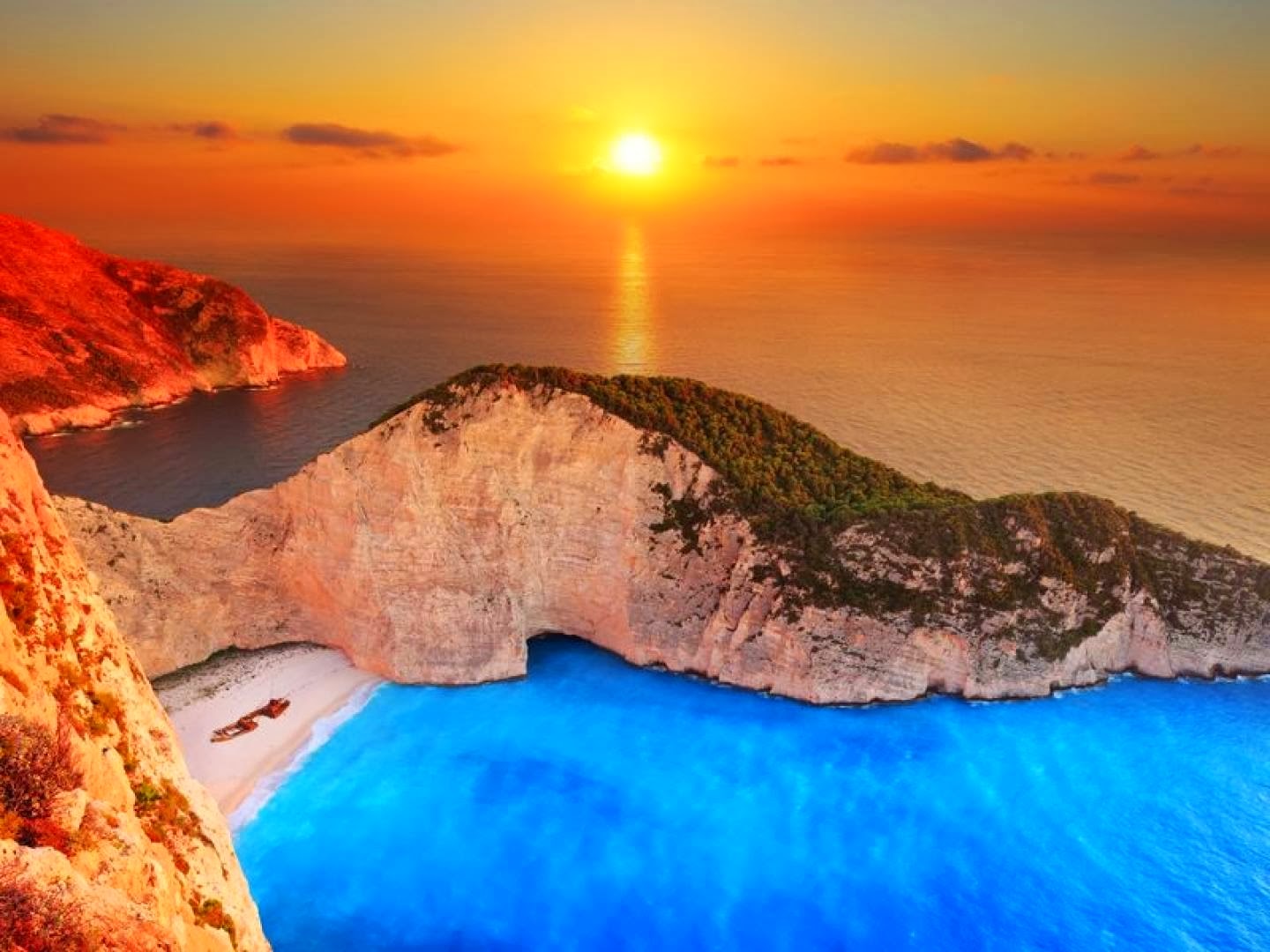
Navagio Beach, Greece

Navagio Beach or the Shipwreck, is an isolated sandy cove on Zakynthos island and one of the most famous and most photographed beaches in Greece. Navagio Beach is often referred to as the Shipwreck Beach or just simply “The Shipwreck” because it is home to the wreck of a ship called Panagiotis that is believed to have been a smugglers ship. The presence of alleged smugglers ship gave Navagio Beach yet another nick name – Smugglers Cove.

This small and isolated, yet strikingly beautiful sandy cove is located on the north-west shore of Zakynthos Island, near the Anafotiria village, quite opposite of island’s capital Zakynthos. The area is defined by its sheer limestone cliffs, white sand beaches, and clear blue water, which attract thousands of tourists yearly. The strip of beach is accessed only by boat, but you can see it from above if you stand on the high side of the cliffs that overlook it.


Navagio Beach was originally known as Agios Georgios. Then sometime in 1981, the Greek authorities were tipped that a freightliner in the waters around Zakynthos Island is smuggling contraband which included cigarettes, wine and women, and a chase began. Stormy weather and bad visibility resulted in the ship running aground right on Navagio Beach. The ship was abandoned and still rests buried in white sandy dunes of the beach that now bears the nickname Shipwreck.


{ Read More }


Friday, 4 April 2014

Sveti Stefan, Montenegro

Sveti Stefan is a town in Montenegro. Previously a fishing village, in 1960 it was converted into the old town, with its tower, narrow streets, shops and small churches, remained unchanged.


Sveti Stefan is an unusual and unique place not only at Montenegro or Budva's Riviera but in the whole Mediterranean. It stands on the cliff of a rocky island with roofs red like rubies. A sand isthmus looking like a stem connects it with the land. It came into existence in a unique way.


{ Read More }


Thursday, 3 April 2014

Grand Falls – Flagstaff, Arizona, USA

Grand Falls of the Little Colorado River located in Flagstaff, Arizona is a 185 foot water fall. There is a rush of muddy water in the fall during the spring. March and April are the best times to see the water fall; the river could dry up during other months.

The falls were created approximately 100,000 years ago by lava flowing from Merriam Crater. The crater is a cinder cone located ten miles to the southwest of the river. The river was forced out of the gorge, passed by the dam and then back to the original destination by the lava. The result was a water fall that is an off color during certain months of the year.

The Reservation of the Navajo Indians is home to the Grand Falls. There is no cost for admission to the area which has an overlook with picnic tables. Dogs should be on a leash to prevent disturbing the livestock and visitors are asked to keep the area clean. Visitors are asked to stay out of the riverbed since it can be rather dangerous.

The uniqueness of the Little Colorado River's Grand Falls makes them an ideal place to visit. Anyone close to the Navajo Reservation should make it a point to stop and take in the scenery.


{ Read More }


IconIconFollow Me on Pinterest

News

Coming soon

Partners

_

What's Hot